Aim:
To create a Topology Network feature class and validate Topology for the given Map using the chosen Point attributes.
Procedure:
Concept: Topology is the mathematical study of shapes and topological spaces. It is an area of mathematics concerned with the properties of space that are preserved under continuous deformations including stretching and bending, but not tearing or gluing. Entities are geometries which are mostly digitized manually. Given the manual exercise of digitizing map for larger sections of an area, chances are that many of the features do not comply with the obvious logical or physical consistency of how it is supposed to be. Example, an junction point should have at least two roads polyines in its side or a coast should be along one side of an Area Polygon,… Based on your feature geometry and kind of error-free relationship you want to establish, you have a choice to choose a or combination of rules from the 32 pre-defined rules. Same location of coordinates, boundaries, or nodes, chances which is suspected for any digitization errors can be detected and fixed through the methodology of geodatabase topology. The process can help you define a framework of spatial relationship among your feature datasets and overall to better manage your geographic data.
Step 1: Map Input
Identify the entities component for the location dataset. For this session, Point (Settlements), Line (Roads) and Area (Water bodies) were all digitized from the given topographic map of Nellore & Cuddapah Districts. The line entity “Roads”, will be extensively validated in this session
Step 2: Map Processing
- · Right-click the target feature-data set and click on “Topology” to create a new Topology Feature class. Customize the feature class with a Name, Feature Classes that will be involved, ranks (feature classes) and ultimately the Rules that will be the benchmark for validation.
- · For this session, “Line must not have dangles” rule was chosen to validate smooth connection between the endpoint nodes of Road lines.
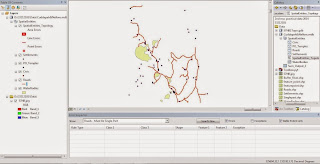
- · Start Editing -> click on the “Error Inspector” under Topology tool bar to generate a summary of feature classes that do not comply with the chosen rule.
- · On the error inspector window click on the error, to understand the nature and scope of the error. Edit vertices or features to fix errors or mark as exception for those features you think is legitimate. This can be achvied by Right-clicking the error row in the window.
- · Click “validate topology in current extent” tool to make sure your map is error free.

Step 3: Map Display
Take a snap screen of the error-inspector window, post topology validation.
Conclusion:
Topology validation for the chosen road polyline is performed using geo-database topology tools of ArcGis 10.1.
No comments:
Post a Comment