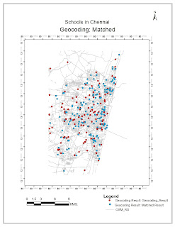
To Geo-code the address of Schools.
Procedure:
Step 1: Map Input
Address of Schools in Excel or Stand-alone Table Format (With Road Name, City, State), Reference Data (Census Data or OSM data for Non- US, possibility).
Step 2: Map Processing
1. Enable the Geo-coding Extension with ArcGis
2. Build an Address Locator using “Create Address Locator” Tool of Geocoding toolbox or by right-clicking on your geo-database (Feature Dataset).
 3. On the Address Locator Style Specify “Single Field” (This is mostly for Non-US, where the Address sequence does not follow a nationally uniform sequence. For US it is best to use “Dual Ranges”)
4. Add on the Reference Data as the OSM Data set and set the Filed Map with appropriate Field Name and Alias Name. Make sure to set the primary key field to Street Name or House Number, through which the address matching will be processed.
5. Now, to initiate Geo-coding of School Address Table, Click on the Geo-code address icon of the extension tool bar. Specify the attribute field name, which will link with the address locator’s primary key field. One may also specify, Geo-coding Options of Spelling Sensitivity, Minimum Candidate Score,….
Step 3: Map Display
7. Generate Map Outputs of Geo-coding result, Matched Results (Select by attributes of Table and Export as shapefile) and Screen shot of results page.


No comments:
Post a Comment